Home | Who are we ? | Contact Us | Batteries Price List | 4Powerpure Reverse Osmosis | Technical Information page | Video Works | Boating Hobby | Job Opportunities | Support / Visit these FREE sites

4 Power...Batteries, Video work... and more

EPIRB

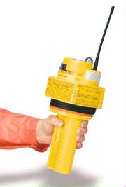
An EPIRB is a small battery-powered transmitting device that is carried on board.. As the name implies, it is used only in case of emergency and usually only as a last resort when your marine radio is inoperable or out of range.

There are several types of EPIRBs. If disaster strikes, some float free and automatically activate; others must be activated manually. All EPIRBs float and will send out a continual signal for 48 hours. Since EPIRB signals are primarily detected by satellites that pass overhead, occasionally there may be a delay in detection (perhaps an hour) because there is no satellite currently in the area to pick up the signal. Once activated, the EPIRB should be left on to make sure the signal is available for detection by the satellite and for purposes of homing in on your location.

EPIRBs that operate on 121.5/243 MHz (category II) are the least expensive and least capable. They may cost around Lm400.00. These were designed in the 1970's to alert aircraft flying by. They are not well suited for satellite detection because of the problem of distinguishing them from other signals on the same frequency. Often, multiple passes of the satellites are required to identify the signal, which can definitely delay the rescue.

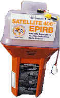
The one you want is the 406 MHz EPIRB (category I) which includes a 121.5 MHz signal which is mainly used for homing. This one is more expensive (around Lm1000.00) but what is your life worth? Response time to the 406 EPIRB is dramatically reduced and the position information it provides is much more accurate. Additionally, the 406 EPIRB's signals are coded, allowing non-EPIRB signals to be filtered out. They also provide other valuable information which will help the search and rescue efforts. At the time of purchase you can register your EPIRB and part of the coded signal will include your name, address, phone number, vessel description, and an emergency contact shoreside who will know of your plans and capabilities. Once the satellite picks up the signal and transmits it back, the search and rescue team knows where you are and who you are.

The 406 EPIRB is carried on all U.S. flag merchant vessels and is required on commercial fishing vessels operating beyond three miles from shore (unless they do not have a galley and sleeping facilities). EPIRB's are also required to be licensed by the Federal Communications Commission. They should be listed on your ships station license. Although EPIRBs are not required on recreational vessels, the U.S.C.G. strongly recommends them and strongly suggests that the choice be the Category I, 406 MHz model. Its long-reaching, long-lasting signal can make a significant difference in the speed and effectiveness of rescue efforts.

In a recent test of the 406 MHz model, a Naval Academy midshipman found out how effective it was. The test signal was identified within four minutes and pinpointed within 15 minutes. If that is not enough to convince you, the comparison chart below may help you make up your mind whether or not you want to "bet your life" to save a little money.

Category I, 406 MHz model

Category II, 121.5/243 MHz model


Global detection - Regional satellite
earth station not needed

Regional earth station needed - not
available in many ocean areas.
Potential for detection by overflying
aircraft.


Reliable beacon with low false alarms
and high probability of detection.

Beacons often incompatible with satellites.
Designed for detection by aircraft. High
number of false alarms is typical.


Beacon signal coding and exclusive
international use of the 406 MHz
frequency band for distress beacons
assures a signal received is from an
EPIRB - no problem with false alerts
from non-beacon sources

High false alert rate due to alerts
generated by other transmitters within
the 121.5 MHz


1.5 nautical mile accuracy and a
second signal provided to use for
homing.

10-20 nautical miles accuracy. Search
and rescue forces can home on the
primary signal.


Beacon is coded with owners name,
address, phone, vessel type etc.

No way to know whether signal is from
an EPIRB, similar aviation beacon, or
non-beacon source. No coded information
with signal.


Good ambiguity resolution, i.e. can
promptly launch rescue unit to a
known position with an alert from
a single satellite pass.

Hard to know which of two separate
positions calculated with first satellite pass
is the beacon location. Usually must wait
for a second satellite pass to resolve.


gpirb.jpg

epirb.jpg

Enter content here

GPIRB - the smart EPIRB

This is the first of a new generation of emergency beacons. GPIRBs (Global Position Indicating Radio Beacon) combine the latest in GPS and 406MHz EPIRB (Electronic Position Indicating Radio Beacon) technology, and add extraordinary precision to your emergency distress signal. If you are a boater who operates offshore or in the Great Lakes, this could be the best "life insurance" policy you could own.

The GPIRB, with its built in GPS, determines and broadcasts its own location. This shortens the time required to get an accurate fix on the beacon location and saving valuable time at the beginning of an SAR (Search And Rescue) operation.

The unit comes with a float-free bracket that releases it if it is submersed as in a sinking. There is a manual mode to turn the unit on manually and a test mode which should be used on a frequent basis to test the operation. It has a minimum 48 hours operating life, 8-channel internal GPS and comes with a lithium battery.

What's the difference between 406MHz EPIRBs and the new GPIRB?

The position of a 406 MHz EPIRB is determined by calculations using the Doppler shift in the beacon's distress signal which occurs as satellites approach and recede in overhead orbits. The accuracy of the calculations is determined by the number of signal bursts received by the satellites. Accuracy is enhanced when a satellite passes directly overhead, because the satellite receives the greatest number of signal bursts. The only real problem with the system is that it takes time for an accurate fix to be acquired.

In contrast, the new GPIRB takes an active role in determining its own position. When activated, its internal GPS finds its own position, just like an onboard GPS. Having located itself, it broadcasts its identity and position on 406MHz. It will then shut down for 20 minutes to conserve power, and repeat the process of locating itself and rebroadcasting. It will continue to update its position every 20 minutes as long as it is active. The advantage of a GPIRB is that an accurate fix is almost instantly available. Its frequent update allows rescuers to compute drift accurately, and direct SAR teams directly to you -- difficult to do with the time delays of an EPIRB.

Search and Rescue Radar Transponder (SART)

Search and Rescue Transponders (SARTs) are designed to help locate vessels in distress or survivors in a life raft. They can be detected by radars carried onboard most vessels. SAR and multi-purpose aircrafts are usually equipped with radar to detect SARTs as a function of their response capability

A SART transmission is triggered by a signal sent out by radar of a search vessel and shows up on the screen as a series of dots, accurately indicating the position of the SART. SARTs are packaged in approved life rafts for fishing vessels greater than 20 metres to serve as standard detection equipment. They are sometimes carried as optional equipment on fishing vessels less than 20 metres. SARTs are mandatory equipment for 'Safety of Life at Sea' (SOLAS) class vessels and are mounted on the bridge ready for manual transport in the event of an emergency evacuation. They offer an excellent detection device in the event of a distress situation.

Fish harvesters using SARTs should be aware of the following operating procedures:

§                    SARTs should be properly maintained and operated according to manufacturer's standards;

§                    in the event that a vessel must be abandoned, SARTs should be taken aboard the survival craft; and,

§                    SARTs must be manually activated and placed as high as possible clear of obstructions that would impede or supress signals to and from the radar.

Stay safe on a boat.


DO ...wear a lifejacket.
Even strong swimmers need to wear one! Make sure your lifejacket is adequately suited to the type of boating you are planning.


DO ...check your equipment.
Check the boat, the engine, and the safety equipment. Make a check-list to go through each time you take your boat out.


DO ...tell someone where you are going, and when you'll be back.
So they can raise the alarm if you don't return on time.


DO ...check the weather forecast before you set out.
Make sure you are prepared for the worst weather you may encounter.


DO ...use your common sense.
Don't be stupid or show off! Boating can be great fun, but you need to be sensible too!


DO ...overload your boat.
Make sure you obey the maker's instructions. It's better to make two trips safely than put your life at risk and make just one.